
Sir George Everest Cartography Museum Mussoorie , On World Tourism Day, Uttarakhand Tourism Minister Satpal Maharaj marked the occasion by inaugurating the first Cartographic Museum and unveiling a helipad at Sir George Everest in Mussoorie.
Table of Contents
The helipad has been dedicated to the renowned Indian mathematician mountaineer Radhanath Sikdar as a tribute to his incredible achievements. He was an Indian mathematician renowned for his 1852 calculation determining Mount Everest’s height. He became the first person to accurately measure the tallest mountain’s elevation.
These tourism promotion activity is being observed in various places in the state by the Tourism Department on the occasion of World Tourism Day 2023, which has been themed “Tourism and Green Investment” by UNWTO.
During the program held at Sir George Everest in Mussoorie, Uttarakhand Tourism Minister Satpal Maharaj inaugurated the Cartographic Museum and dedicated the helipad to the great Indian mountaineer Radhanath Sikdar.
In his address, Minister Maharaj praised the achievements of Sir George Everest and Radhanath Sikdar in mountain climbing and survey work, dedicating the Sir George Everest Cartographic Museum to all the great mountaineers of India.
This museum is unique as it displays the Great Trigonometric Arc Survey conducted by Sir George Everest and surveys of various Himalayan peaks by Indian mountaineers. It also provides information about various instruments used in surveys.
Tourism Minister Maharaj also provided information about various programs being organized by the Tourism Department in different districts of the state as part of World Tourism Day. He mentioned that under the Best Tourism Village competition organized by the Government of India on this occasion, the village of Sarmoli in Pithoragarh district was awarded the title of the Best Tourist Village.
This competition invited information and presentation from tourist villages in all states regarding various activities and facilities related to tourism, including information on various activities and home stays for tourists.
The award by the Government of India is an excellent example of community participation in tourism in the state.
Anuj Gupta, the Chairman of the Mussoorie Municipal Council, welcomed the tourists arriving in Mussoorie at this museum and encouraged other notable personalities of Mussoorie to provide information to tourists about this new tourist destination.
On this occasion, various programs related to tourism were organized in different places in Almora district, including art, essay, and MTB competitions.
In Pithoragarh district, a three-day National Rafting Championship and angling competition is being organized. Teams from various states, as well as teams from Nepal, are participating in this competition.
In Uttarkashi district, trekking and mountain biking were organized, and a cultural evening was held at London Fort. Additionally, a seminar on tourism and green investment was organized.
Introduction to the George Everest Cartography Museum
The stunning Himalayan mountain range has captivated explorers and adventurers for centuries. As the ambitious sought to conquer these peaks, cartographers played a pivotal role in mapping the terrain and documenting geographical features. The George Everest Cartography Museum in Mussoorie, Uttarakhand pays tribute to these cartographic pioneers and surveyors who helped us better comprehend the majestic Himalayas.
Background on George Everest
The museum is named after Sir George Everest – the Surveyor General of India from 1830 to 1843. Everest was a British surveyor and geographer who conducted the Great Trigonometric Survey across India. This ambitious project aimed to measure the world’s highest peaks in the Himalayas and define the boundaries of British India.
Everest succeeded in calculating the height of Peak XV in the Himalayas as 29,002 ft above sea level. This peak was named Mount Everest in his honor in 1865 after his retirement. His pioneering work laid the foundations for future exploration and mountaineering expeditions in the region.
Overview of the George Everest Cartography Museum
In 2022, the Uttarakhand tourism department inaugurated the George Everest Cartography Museum in Everest’s former Mussoorie home. Known as Park Estate, Everest resided at this property from 1832 to 1843 during his Great Trigonometric Survey expeditions.
The museum showcases the evolution of cartography and honors the surveyors and explorers who expanded our understanding of the Himalayas. It serves as an educational resource with interactive exhibits and displays cureated with support from the Survey of India.
Highlights of the George Everest Cartography Museum
What is George Everest Cartography Museum famous for?
- Interactive map galleries with antiquated maps, aerial views, and 3D topographic models
- Art galleries with cartographic paintings and illustrations
- An outdoor observatory with opportunities for practical surveying
- A library with journals, logbooks, and memoirs of key explorers
- Sections profiling the life’s work and adventures of Sir George Everest
History of Park Estate and Its Significance
To appreciate the museum’s historical significance, it’s important to understand the background of Park Estate where it is housed.
Park Estate – Everest’s Mussoorie Home
The museum is located in the Hathipaon region of Mussoorie at Park Estate – in the former dwelling of Sir George Everest from 1832 to 1843. Constructed in 1832, it was one of the first houses built in Mussoorie and served as Everest’s home and laboratory.cartography surveying surveying mountaineering
Perched at 8,000 ft above sea level, the secluded estate offered sweeping views of the Doon valley – ideal for Everest’s survey work. Using Park Estate as a base, Everest undertook pioneer mapping expeditions into the Himalayas.
Restoration Efforts by Uttarakhand Tourism Department
After years of standing dilapidated, the Uttarakhand tourism department invested ₹23.5 crore assisted by the Asian Development Bank to restore Park Estate and develop the property into a museum.
As part of the restoration project – eco-friendly log huts, food stalls, mobile toilets and heritage walking paths were added. This enables visitors to relax and enjoy the estate grounds after exploring the museum exhibits inside the 19th century mansion.
The property provides a unique opportunity to step back in time into the life of Sir George Everest. Understanding Everest’s survey methods firsthand deepens one’s perspective of cartographic history.
Tribute to Radhanath Sikdar – Measurer of Everest
A key highlight of the museum is the tribute section to mathematician Radhanath Sikdar – who worked alongside Everest. Sikdar achieved the historic feat in 1852 of measuring Mount Everest’s exact height (29,002 feet) for the first time through complex trigonometric calculatione.
The helipad at Park Estate was named in Sikdar’s memory given his pivotal role in this discovery. It was Sikdar’s computations with data from Peak XV that allowed the formal renaming to Mount Everest. His achievements paved the wave for accurately mapping the Himalayas.
“Sikdar’s remarkable calculations and contributions must never be forgotten – it is the foundation that pioneer mapping of Everest and the Himalayas is built on.”
Minister Satpal Maharaj’s Comments
During the museum inauguration on World Tourism Day 2022, Uttarakhand Minister Satpal Maharaj spoke admirably about Sikdar and Everest:
“Their achievements in mountaineering and surveying must be forever remembered. We stand proudly on the shoulders of these visionaries who unveiled the magnificence of the Himalayas.”
The helipad plaque is a fitting memorial to Sikdar’s efforts in putting Mount Everest on the map for the first time in history.
George Everest Cartography Museum- Unparalleled Exhibits -Himalayan Peaks and Beyond
As a one-of-a-kind institution, the George Everest Cartography Museum offers interactive exhibits to immerse visitors into the evolution of Himalayan exploration and cartography:
Great Trig Survey Exhibits
Visitors can explore relics from Everest’s Great Trigonometric Survey like:
- Original sketches, maps, and survey sheets
- Handwritten logbooks and hiking diaries
- Albums with antique photographs and daguerrotypes
These provide insights into the Great Trig process and early surveying techniques used by Everest’s team.
Himalayan Peak Surveys
In later years as Everest’s methods were refined, Indian mountaineers conducted detailed mapping surveys of prominent Himalayan peaks.
The museum showcases extensive records from these Indian surveyor expeditions including:
- Nanda Devi (25,643 ft) – mapped in 1856 by expedition led by Henry Haversham Godwin-Austen
- Kangchenjunga (28,169 ft) – mapped in 1852 by Radhanath Sikdar
- K2 (28,247 ft) – mapped in 1856 by Thomas Montgomerie
- Kanchenjunga Main (28,208 ft) – detailed sketches mapping glaciers and routes by Douglas Freshfield expedition (1899)
These provide insights into the step-by-step process employed to accurately measure the world’s highest peaks for the first time.
Everest’s early field notebooks with sketches are also displayed – indicating how his techniques were subsequently refined in later surveys.
Evolution of Equipment
With dedicated information boards, the museum sheds light on the diverse equipment and instruments essential for these ambitious surveys.
Visitors learn how these tools evolved from Everest’s early expeditions in the 1830s to advanced surveys in the early 20th century:
Key Instruments and Tools
- Theodolites – primary survey device to measure horizontal and vertical angles
- Spirit levels – determined elevations and gradients
- Steel tape measures – calibrated for distance measurement
- Telescopic sights – mounted onto theodolites for precision alignment
- Baseline bars – calibrated metal rods to measure base lines
- Plane tables – stable surface for field sketching and map drawing
As methods were refined, aerial photography and binocular cameras were used to capture dimensions accurately. High-qualityDIGI altimeters were integrated in the early 20th century.
By showcasing this equipment evolution, the museum provides deeper context into the survey techniques pioneered by Everest and his colleagues.
Educational Aspects – Understanding Pioneering Methods
Beyond just exhibits, the George Everest Cartography Museum serves an important educational purpose.
Learning Objectives
The museum allows visitors to:
- Understand early cartographic and survey techniques employed in the Himalayas
- Appreciate the step-by-step process in mapping uncharted mountain peaks
- Visualize how quantitative dimensions were captured without digital technology
- Gain insights into advancements in instrumentation and tools for surveying
With guided tours and information displays, complex principles are simplified for the average visitor – bringing pioneering discoveries to life.
Practical Demonstrations
The outdoor observatory has trained guides providing practical demonstrations of plane table surveying and theodolite use.
Visitors can even look through an antique theodolite or tentatively try sketching topographic features onto a baseline map. This helps conceptualize just how methodical and skilled this technique was.
Through active participation, the core principles of triangulation calculation and terrestrial sketching are reinforced. Visitors leave with a profound admiration for the surveyors who relied on these manual techniques.
The George Everest Museum provides the perfect opportunity for tourists to learn about Sarmoli’s unique offerings before embarking on a visit.
Key Features of the George Everest Cartography Museum
Beyond the intriguing exhibits, displays and demonstrations – the museum has added modern amenities to enrich the visitor experience:
Art Gallery
A key highlight is the art gallery with various antique paintings, sketches, and etchings depicting the Himalayan landscape. Many are renderings traced back to Everest’s preliminary survey sketches.
Seeing early artistic impressions of the Himalayas adds texture and perspective to the scientific aims of the pioneers.
Reference Library
For those wanting an in-depth understanding of cartographic history and Himalayan mountaineering, the museum has an expansive library and archive. Key publications include:
- Great Trigonometric Survey of India logbooks and reports
- Copies of handwritten journals by Nain Singh Rawat (legendary explorer trained in surveying methods by Everest)
- Historical maps, monographs, and literary accounts of early Himalayan climbing expeditions
- Recent academic reference books on cartography principles and techniques
Scholars can spend hours going through these antiquated resources that are exclusively available at the museum premises.
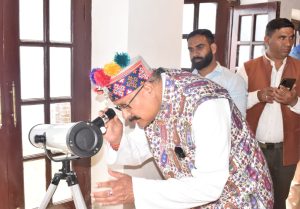
Observational Astronomy at at George Everest Cartography Museum
Keeping with George Everest’s fascination with the cosmos, the museum organizes regular observational astronomy sessions at night. Visitors can observe the clear night skies over Mussoorie using high-powered telescopes aided by knowledgeable astrophysicists.
Seeing majestic Himalayan peaks by day and gazing at the milky way by night – the George Everest Cartography Museum offers multi-dimensional perspectives into this enchanting landscape.
Preserving an Historic Legacy in Cartography and Mountaineering
As Minister Maharaj highlighted in his museum inauguration speech – the George Everest Cartography Museum plays a profound role in preserving Uttarakhand’s legacy at the intersection of cartography and mountaineering.
It was in the towns of Mussoorie and Dehradun that pioneering survey institutions like the Survey of India were founded alongside the ascent of Himalayan mountaineering as a formal sport. Uttarakhand served as the cradle for these interlinked pursuits.
The museum provides the opportunity to not just understand facts and discoveries – but to emotionally travel back in time when ambitious explorers sought to accomplish the impossible and put these peaks on the map.
Through interactive exhibits and demonstrations, visitors young and old can reconnect with the wonderment and audacity that defined the quest to unveil the majestic Himalayas. It inspires a new generation to ponder how such mammoth feats were achieved without modern technology.
In a world dominated by smartphones, the museum provides a refreshing outdoor-oriented experience highlighting the ingenuity behind the science and art of cartography. The Himalayan terrain presents a timeless backdrop to appreciate the spatial thinking, creativity and persistence that great surveyors like Sir George Everest and Radhanath Sikdar epitomized.
Visit the George Everest Cartography Museum
The George Everest Cartography Museum provides the perfect opportunity to understand the storied history behind cartographic depictions of the Himalayas alongside appreciating stunning topographic vistas firsthand.
Plan an upcoming visit to Mussoorie and explore interactive galleries showcasing antique maps, artifacts, and displays detailing the quest to systematically document the highest peaks on Earth.
Let the spirit of adventure and discovery come alive as you trace the footsteps of the fascinating individuals who put Mount Everest firmly on the map!
Sarmoli Village – Best Tourism Village Award
During the museum inauguration ceremonies, Minister Satpal Maharaj proudly announced that the Sarmoli Village of Pithoragarh district had received the Best Tourist Village designation by the Government of India.
Background on Sarmoli Village
Sarmoli Village is a remote Himalayan tribal village nestled in the Munsiyari region of the Himalayas. Surrounded by the Panchachuli mountain range with elevations from 10,000 to 22,000 feet, Sarmoli offers unparalleled views and natural wilderness.
The village has actively promoted sustainable tourism practices and pioneered the homestay model for visitor accommodations. This provides employment and uplifts the community while preserving cultural heritage.
National Level Recognition
In the national level Tourism Village competition organized in 2022, Sarmoli Village was recognized as the Best Tourism Village among entries from 35 states and union territories.
The parameters included community participation, environmental preservation, and tourism infrastructure. Sarmoli’s responsible tourism model made it a stand-out entry aligned with the competition’s sustainable development goals.
As Minister Maharaj highlighted, this award brings pride to Pithoragarh district and shines a light on Sarmoli Village as an inspiring model for balanced tourism practices in the Indian Himalayas.