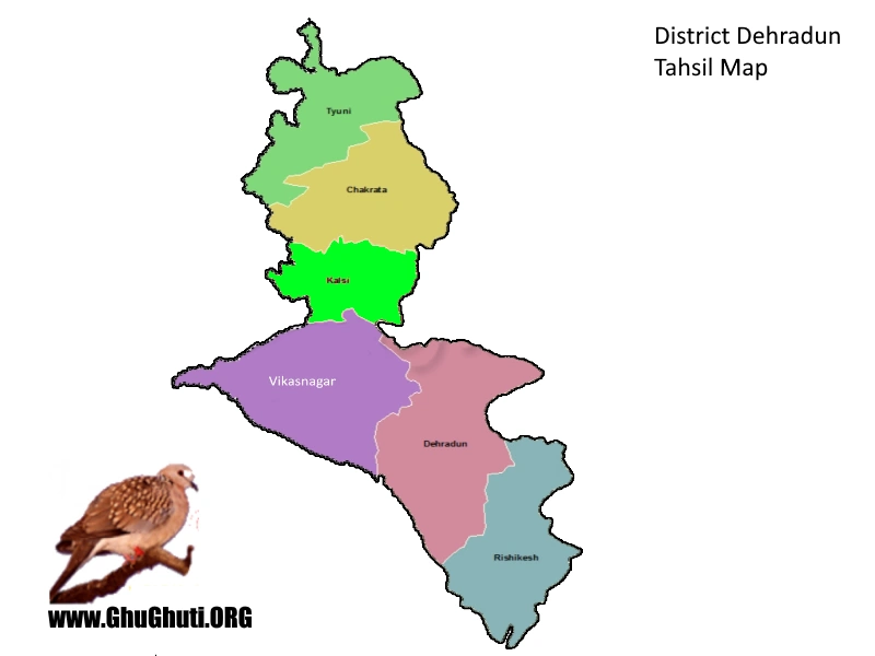
Dehradun map consists of its all six tehsils, which are namely:
- Chakrata
- Dehradun
- Kalsi
- Tyuni
- Vikasnagar
- Rishikesh
Dehradun is one of the 13 districts of northern Indian state of Uttarakhand. It fall in the Garhwal division of the state. It has six tehsils. As per the census data of 2011, it is the second most populous district of Uttarakhand, after Haridwar. As of 2011 census, Dehradun district has a population of 1,698,560. It has the highest literacy rate in the state at 85.24% (90.32 for males, 79.61 for females). The borders in below map of Dehradun district touches:
Dehradun Map with Tehsils and Borders:
Few Facts about Dehradun District:
- Dehradun has a rich history and many mythological tales. The Hindu epic Ramayana mentions that lord Ram along with his younger brother Lakshman came here after defeating Ravana.
- Many ancient temples, ruins, statues, stone figures and archaeological remains have been found in this place.
- Sikh guru Ram Rai Singh established his Dera (camp) in Dehradun valley around 1676.
- Its proximity to Mussoorie and many other hill station, makes it a great weekend getaway.
- Dehradun’s pleasant and unpredictable weather and beautiful landscapes make it a perfect place to settle down after retirement.
- The city of Dehradun has many weekend getaways and picnic spots nearby. Such as Shikhar falls, Bhatta falls, Guchhupani (Robber’s cave), Lachhiwala, Malsi Deer park, Sahastradhara and many more.
- The yoga capital of the world – Rishikesh, is just an hour away from the city. Rishikesh has many meditaion and yoga centers, ashrams and dharamshalas.
Location:
- Dehradun is 258 km away from Delhi, capital of India. It takes almost 6 hours to reach here from Delhi via bus or train and 2 hours in the plane.
- Jolly grant is the nearest airport to Dehradun. It takes about half an hour to reach the airport from the clock tower of Dehradun.