When you explore Bageshwar Map you wil see that it is located in Uttarakhand and forms part of Kumaon Division, along with Nainital. Pithoragarh. Champawat. Almora. Bageshwar, this is a unique district in out of 13 Uttarakhand district in Uttarakhand with four 6 Tehsils located at the confluence between the Saryu River and the Gomati River is nestled near the Saryu-Gomati river.
Tehsil
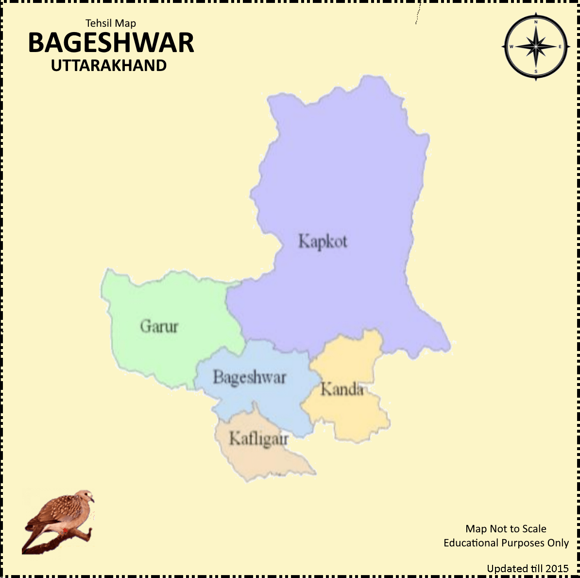
District Bageshwar has six tehsils and one sub tehsil in as follow:
List of Tehsils
- Bageshwar
- Garur
- Kapkot
- Kanda
- Kafligair
- Dug Nakuri
List of Sub Tehsil
- Shama
Bageshwar Map and its Borders
Bageshwar is divided into 6 Tehsils, 1 sub Tehsil and the surrounding districts are also shown on this map. Bageshwar’s borders touch the following districts:
- Chamoli District in the West and North-Wasted
- Almora is located in the South and Southwest
- Pithoragarh District in the East and North-East
Importance of Bageshwar Map PDF
A map is an essential tool for any traveler or visitor to Bageshwar. It helps in navigating through the town, locating important landmarks, and planning a trip effectively. With the advancement of technology, maps are no longer limited to traditional paper formats. The availability of digital maps, such as the Bageshwar Map PDF, has made it even more convenient for tourists to explore the town.
Bageshwar District: Here’s some interesting facts.
- Bageshwar has a population of 259.898 according to 2011 Census. This includes 124.326 men and 135.572 women. This is the third-least populous district of Uttarakhand, after Champawat.
- History: The Katyuri Kings ruled the region that was once called Danpur in the 7th Century. It was initially a part of the Almora District before becoming an independent district in 1997.
- British influence: This area had been under Gorkha control for 24 years before the East India Company overthrew them in 1814. The British then took it back.
- Bageshwar’s natural beauty is unmatched. It is known for its pristine glaciers and flowing rivers.
- Bageshwar is home to many ancient Hindu temples including Bagnath Temple, Baijnath Temple. Name of the district is derived by Bagnath Temple.
- Kumaoni is a language that has a special place in Kumaoni culture. Hindi, however, is also widely spoken. Bageshwar is a district where Sanskrit, Hindi and Hindi-based languages are spoken.
- The Post-Independence history: Bageshwar, after gaining its independence, was a part of the Almora District and only had 1740 inhabitants, according to data from India’s 1951 Census.
Google Map Bageshwar Map Link
FAQ
Why is the Bageshwar Map PDF important for travelers?
The Bageshwar Map PDF is important for travelers because it helps in navigating through the town, locating important landmarks, and planning a trip effectively.
What are the advantages of the Bageshwar Map PDF?
The advantages of the PDF Map include portability, detailed information about roads, attractions, landmarks, hotels, and restaurants, user-friendliness, and offline accessibility.
How can the Bageshwar Map PDF enhance the travel experience in Bageshwar?
The PDF Map enhances the travel experience in by providing precise locations of attractions such as Baijnath Temple, Kausani, Pindari Glacier Trek, Chandika Temple, and Gauri Udiyar. It also highlights nearby facilities, scenic spots, accommodations, and eateries.
Why is offline accessibility a major advantage of the Bageshwar Map PDF?
Offline accessibility is a major advantage of the Bageshwar PDF Map because it allows travelers to rely on the map regardless of their location or the availability of an internet connection. It eliminates the need for mobile data or Wi-Fi, providing a reliable navigation tool even in remote areas with limited or no network coverage