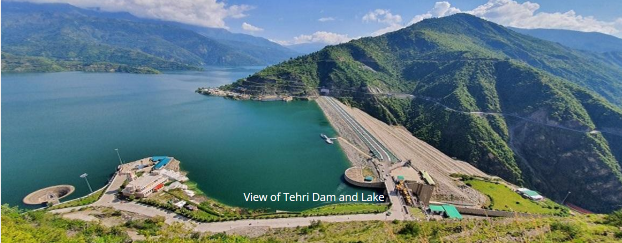
The Tehri Dam is a multi-purpose rock and earth-fill embankment dam situated on the Bhagirathi River near Tehri in Uttarakhand, India. With a height of 260.5 meters (855 feet), Tehri Dam is the tallest dam in India and ranks 12th tallest in the world.
The dam impounds the waters of the Bhagirathi and Bhilangana rivers to create a massive reservoir with a capacity of 3.54 cubic kilometers. Commissioned in 2006 after decades of delay and controversy, the Tehri Dam is now fully operational, serving the purposes of hydroelectricity generation, irrigation, municipal water supply and flood control and hotspot for water adventure tourism in Uttarakhand , now the tehri dam lake is being developed as a preimer water sport complex in Uttarakhand and being tagged as mini maldives of Uttarakhand.
Introduction Tehri Dam
The Tehri Dam project was conceived in the 1960s as a multi-purpose endeavor to harness the hydropower and irrigation potential of the rivers in the Himalayan region of Uttarakhand. Preliminary investigation began in 1961 under Prime Minister Jawaharlal Nehru. The dam’s initial design had a planned capacity of 600 megawatts (MW), which was later increased to 1000 MW.
The dam is located near Tehri town in the hilly Tehri Garhwal district. It sits at the confluence of the Bhagirathi and Bhilangana rivers, which are major tributaries of the Ganges. The Bhagirathi holds special religious significance as the source stream of the Ganges.
With a height of 260.5 meters, the Tehri Dam is the tallest dam in India. Its reservoir has a storage capacity of 3.54 cubic kilometers and a surface area of 52 square kilometers. The dam has a length of 575 meters and base width of 1,128 meters. Its massive size and storage capacity make it ideal for electricity generation, irrigation, municipal water supply and flood control.
History and Construction of Tehri Dam
The planning and design of the Tehri Dam was completed in 1972. At the time, it was slated to have a power generation capacity of 600 MW. Construction began in 1978, but was soon halted due to financial constraints and growing environmental concerns over the project. Local protests also erupted over the large-scale displacement that would result from the dam’s reservoir.
In 1986, with technological and financial aid from the Soviet Union, construction resumed on the project. The geological instability of the Himalayan region posed several challenges during construction. Complex technical solutions had to be implemented to make the dam suitable for the seismic zone. The project also faced constant shortage of funds due to cost overruns.
Tehri Hydro Development Corporation (THDC) was formed in 1988 to supervise the civil works on the dam. In 1990, the power generation capacity of the project was increased to 1000 MW. By the early 2000s, the first two generators with a capacity of 250 MW each had been installed. Finally in 2006, the full dam with four 250 MW generators was commissioned, after almost three decades of work. Over 100,000 people were displaced by the project.
Main Purposes and Benefits
The Tehri Dam is a multi-purpose project, serving various needs through:
- Hydroelectricity generation – Installed capacity of 1000 MW that adds valuable clean energy to India’s national grid
- Pumped storage hydroelectricity – Additional 1000 MW capacity to store and release power during peak hours
- Irrigation – Reservoir waters channeled through canals to irrigate over 2.7 million acres of land
- Drinking water supply – Supples over 600 million litres per day to Uttarakhand, Uttar Pradesh, Delhi and other states
- Flood control – Dam’s massive reservoir capacity helps modulate flood waters during monsoons
The dam has thus brought electricity, irrigation, drinking water and flood control benefits to millions of citizens in Northern India. It has also given a major boost to the region’s agricultural output and productivity.
Salient Features
The Tehri Dam is a rock and earth-fill embankment dam. It is constructed from a combination of rocks, gravel and earth. Key features of the dam include:
- Height – 260.5 meters (855 feet)
- Length – 575 meters (1,886 feet)
- Crest width – 20 meters (66 feet)
- Base width – 1,128 meters (3,701 feet)
- Dam volume – 8.47 million cubic meters
The dam’s reservoir has a:
- Surface area – 52 square km (20 square miles)
- Catchment area – 7,320 square km
- Capacity – 3.54 cubic kilometers (2.87 MAF)
- Dead storage – 1.60 cubic kilometers
- Live storage – 1.94 cubic kilometers
Water from the reservoir is channeled to the turbines in an underground power station downstream via multiple penstock pipes. The station houses four 250 MW Francis turbine-generators. The total installed capacity of the Tehri power plant is 1000 MW.
Geographical Details
The Tehri Dam is situated at the boundary between the Great Himalayas and the Lesser Himalayas. It is located near Tehri town in the hilly Tehri Garhwal district of Uttarakhand. The coordinates of the dam site are 30.37°N 78.47°E.
The dam is built on the Bhagirathi River, which originates from the Gangotri glacier approximately 200 km upstream. The Bhilangana River, originating 50 km upstream from the dam site, is also dammed and joins the Bhagirathi at the reservoir.
The region has an average annual rainfall of 1800 mm. Nearly 80% of this occurs during the monsoon months of June to September due to the South Asian monsoon system. The rivers carry high sediment loads from the soft sedimentary rocks and loose soils of the steep Himalayan slopes. Snowmelt also contributes significantly to river flows during the summer months.
Sedimentation Concerns and Management
The high sediment content of the Bhagirathi and Bhilangana rivers is a major concern for the Tehri Dam reservoir. The reservoir has an estimated life of 870 years at 50% capacity. However, the annual sediment load into the reservoir is around 86 million cubic meters, requiring active management.
Various measures were incorporated into the dam design and watershed to manage sedimentation:
- Designed 50m high silt flushing tunnels with 80m upstream settling basin
- Additional 25m high emergency flushing tunnels
- Construction of 8 hydropower dams upstream to trap sediment
- Reforestation and soil conservation measures in the catchment area
- Regular bathymetric surveys to measure reservoir sedimentation
- Dredging and hydraulic flushing as needed
Ongoing watershed management and sediment monitoring is crucial for the functioning and longevity of the Tehri Dam. Satellite data indicates higher levels of sedimentation than originally estimated.
Environmental Impacts and Resettlement Issues
The Tehri Dam prompted major environmental controversies and protests during its construction. Activists like Sunderlal Bahuguna highlighted threats to the fragile Himalayan ecosystem. Concerns were also raised about biodiversity loss, deforestation and downstream river health.
Additionally, the project displaced over 100,000 people, submerging their homes, lands and villages. The oustees faced issues like homelessness, unemployment, loss of livelihood and cultural identity. Many did not receive proper compensation or amenities in resettlement colonies.
To address environmental concerns, measures like compensatory afforestation, wildlife habitat improvement and erosion control were implemented. Resettlement and rehabilitation packages were offered to project-affected families to facilitate their transition and compensate loss. However, post-project monitoring indicates mixed results on both environmental and social parameters.
Conclusion
The massive Tehri Dam stands tall as the highest dam in India, showcasing the country’s engineering prowess. However, its construction was mired in controversies and delays. While the project brought benefits like electricity, irrigation and water supply, its environmental and social impacts pose a complex challenge of sustainable development. Continuous monitoring and transparent risk assessment are vital for India’s infrastructural megaprojects. The Tehri Dam serves as an important case study highlighting both the opportunities and limitations of such multi-purpose river valley projects.
On which river is the Tehri Dam built?
The Tehri Dam is built on the Sangam of Bhagirathi River & Bhilangana River, Bhagirathi River a major tributary of the Ganges in India.
In which state is the Tehri Dam located?
The Tehri Dam is located in the state of Uttarakhand, in northern India.
What is the purpose of the Tehri Dam?
The Tehri Dam serves multiple purposes, including hydroelectric power generation, irrigation, and drinking water supply to nearby regions.
How tall is the Tehri Dam?
The Tehri Dam is 261 meters (856 feet) tall, making it one of the tallest dams in India.
What are the benefits of the Tehri Dam?
The Tehri Dam provides power generation, water storage for irrigation, and drinking water supply to millions of people, while also helping to prevent floods in the region.
Which is the tallest dam in India?
Tehri Dam is the tallest dam in India, 261 meters (856 feet) tall, making it one of the tallest dams in India.